Land Survey Equipment Market Size & Growth Forecast 2027–2036, By Segments (Component, End-use, Application, Industry), Regional Demand Trends (North America, Asia Pacific, Europe), Key Country Insights (U.S., Japan, South Korea, Germany, France, Italy), and Competitive Landscape
Market Size and Growth Outlook
Land Survey Equipment Market size was assessed at USD 10.6 billion in 2026 and is poised to grow at a 6.08% CAGR between 2027 and 2036, attaining USD 19.13 billion by 2036. The industry revenue for 2027 is estimated at USD 11.14 billion.
Get more details on this report
Request Free Sample ReportLand Survey Equipment Market Intelligence Snapshot
Regional Market Dynamics
- Asia Pacific held a 37.63% market share in 2026, driven by extensive infrastructure, transportation, and urban development projects that sustain surveying demand across construction, civil engineering, and land administration.
- North America is projected to grow at a 6.78% CAGR, supported by surveying workflow modernization and rising adoption of high-precision technologies for construction, boundary assessment, and infrastructure projects.
Segment Momentum
- Hardware held a 63.05% share in 2026 because surveying relies on durable, accurate field instruments for measurement and site data capture across construction, infrastructure, and land development projects.
- Service Providers are the fastest-growing end-use segment as organizations increasingly outsource surveying work to access specialized expertise, advanced equipment, and faster project execution without maintaining in-house capabilities.
Market Expansion Drivers
- Rapid infrastructure development and urbanization increasing demand for precise geospatial mapping tools.
- Adoption of GNSS, drones, and LiDAR technologies improving surveying accuracy and efficiency.
- Expanding environmental monitoring and disaster management initiatives requiring advanced surveying systems.
Leading Market Participants
- Prominent companies in the land survey equipment market include Trimble Inc. (United States), Hexagon AB (Sweden), Topcon Corporation (Japan), South Surveying & Mapping Instrument Co., Ltd. (China), Hi-Target Surveying Instrument Co., Ltd. (China), Shanghai Huace Navigation Technology Ltd. (China), Stonex Srl (Italy), Suzhou FOIF Co., Ltd. (China), Leica Geosystems AG (Switzerland).
Global Market Forecast Snapshot
Market Outlook
- 2026 Market Size: USD 10.6 billion
- 2027 Estimated Market Size: USD 11.14 billion.
- Projected Market Size: USD 19.13 billion by 2036
- Growth Forecast: 6.08% CAGR (2027-2036)
Regional and Segment Outlook
- Leading Regional Market: Asia Pacific
- High-Growth Regional Hub: North America
- Core Revenue Segment: Hardware (Component) | Commercial (End-use) | Inspection (Application) | Mining & Construction (Industry)
- Emerging Opportunity Segment: Software (Component) | Service Providers (End-use) | Monitoring (Application) | Agriculture (Industry)
Market Growth Drivers and Industry Trends
Rapid infrastructure development and urbanization increasing demand for precise geospatial mapping tools
Rapid infrastructure development and urbanization will drive the land survey equipment market growth as construction, transportation, utilities, and urban planning projects require accurate information about terrain and land characteristics. Expanding development activity increases the need for precise measurement and mapping during site assessment, design, construction, and land management processes. Surveying equipment enables professionals to collect reliable spatial information for increasingly complex development environments, while urban expansion creates sustained requirements for accurate boundary identification, topographic assessment, and geospatial data collection.
Adoption of GNSS, drones, and LiDAR technologies improving surveying accuracy and efficiency
Adoption of GNSS, drones, and LiDAR technologies is boosting the land survey equipment market by improving the speed, coverage, and precision of field data collection. GNSS enables accurate positioning, while drones can capture surveying information across difficult or expansive areas with reduced field effort. LiDAR further supports detailed three-dimensional mapping by capturing terrain and structural information, allowing survey professionals to generate richer spatial datasets. The combination of these technologies is also enabling more efficient workflows in projects where conventional surveying methods may require greater time and physical access.
Expanding environmental monitoring and disaster management initiatives requiring advanced surveying systems
As environmental monitoring and disaster management initiatives expand, demand for the land survey equipment market is increasing because accurate geospatial information is essential for assessing changing terrain and vulnerable areas. Advanced surveying systems can support the mapping of landscapes, monitoring of environmental conditions, and evaluation of areas affected by natural hazards. Detailed spatial data helps organizations identify changes in land characteristics, assess potential risks, and support planning activities associated with disaster preparedness, response, and environmental management.
| Growth Driver | Impact on CAGR | Regulatory Influence | Geographic Relevance | Adoption Rate | Impact Timeline |
|---|---|---|---|---|---|
| Rapid infrastructure development and urbanization increasing demand for precise geospatial mapping tools | 2.20% | Moderate | Asia Pacific, Middle East & Africa | High | Near Term |
| Adoption of GNSS, drones, and LiDAR technologies improving surveying accuracy and efficiency | 2.00% | Moderate | North America, Asia Pacific, Europe | High | Near Term |
| Expanding environmental monitoring and disaster management initiatives requiring advanced surveying systems | 1.60% | High | Asia Pacific, Europe | Medium | Mid Term |
Unlock insights tailored to your business with our bespoke market research solutions.
Click to get your customized report now.
Regional Demand Dynamics
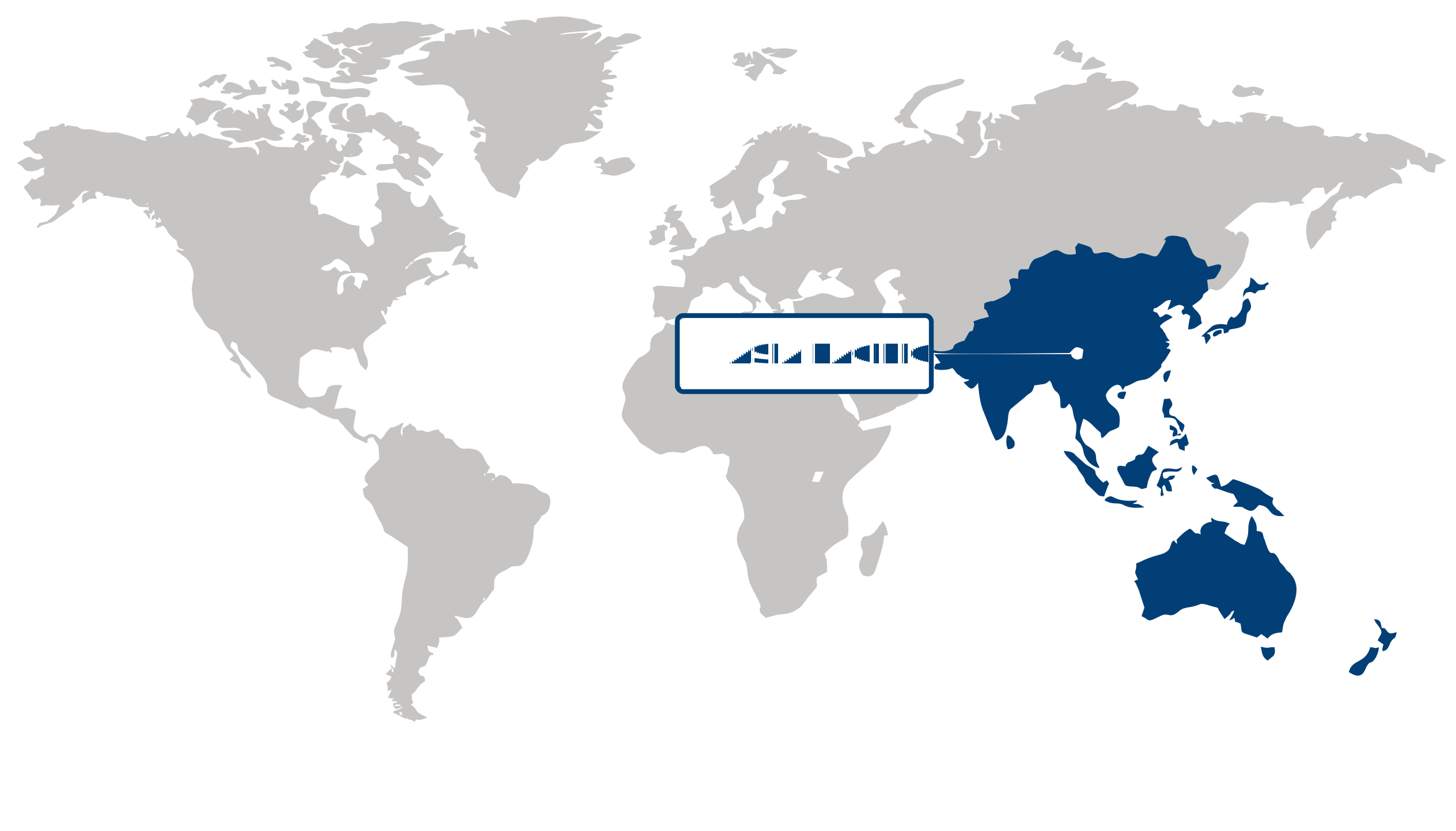
Asia Pacific (Largest Region)
Asia Pacific accounted for the largest share of 37.63% in 2026 in the land survey equipment market, reflecting extensive infrastructure development, urban expansion, and continued investment in construction and land-development activities across the region. Growing requirements for accurate land measurement, mapping, positioning, and site assessment are supporting demand for modern surveying equipment. The expansion of transportation networks, residential and commercial construction, industrial projects, and large-scale urban development is further increasing the need for reliable surveying capabilities. At the same time, greater adoption of digital surveying workflows and technologically advanced positioning solutions is helping improve field productivity, measurement accuracy, and project coordination, reinforcing regional demand.
North America (Fastest-Growing Region)
North America is projected to represent the fastest-growing regional market, supported by ongoing infrastructure modernization, construction activity, and increasing reliance on digitally enabled surveying processes. Demand is being strengthened by the need for precise geospatial data in transportation projects, urban planning, utilities, construction, and land management applications. The growing integration of advanced positioning, digital mapping, and automated data-collection capabilities is also enabling survey professionals to improve efficiency and reduce manual fieldwork. Furthermore, infrastructure renewal initiatives and the continued modernization of surveying practices are creating favorable conditions for broader adoption of sophisticated land survey equipment.
| Parameter | North America | Asia Pacific | Europe | Latin America | MEA |
|---|---|---|---|---|---|
| Innovation Hub i Scale Nascent Developing Advanced | |||||
| Cost-Sensitive Region i Scale Low Medium High | |||||
| Regulatory Environment i Scale Restrictive Neutral Supportive | |||||
| Demand Drivers i Scale Weak Moderate Strong | |||||
| Development Stage i Scale Emerging Developing Developed | |||||
| Adoption Rate i Scale Low Medium High | |||||
| New Entrants / Startups i Scale Sparse Moderate Dense | |||||
| Macro Indicators i Scale Weak Stable Strong |
Key Country Insights
Germany 🇩🇪
Precision Engineering AdoptionGermany prioritizes highly accurate land survey equipment for transportation, industrial development, and engineering applications. Buyers value precision instruments, software interoperability, and dependable performance that supports complex surveying requirements.
France 🇫🇷
Infrastructure Renewal FocusFrance supports demand for modern land survey equipment through transportation upgrades, public works, and environmental management projects. French surveying professionals increasingly seek reliable digital instruments that simplify data collection and regulatory documentation.
Italy 🇮🇹
Heritage Mapping ExpertiseItaly combines demand for modern survey equipment with applications in infrastructure maintenance and cultural heritage documentation. Italian survey professionals favor flexible systems capable of delivering precise measurements across diverse project environments.
Japan 🇯🇵
Urban Survey SolutionsJapan focuses on compact, high-precision survey equipment suited to dense urban environments and resilient infrastructure planning. Japanese organizations continue adopting automated measurement technologies that reduce field time while maintaining consistent accuracy.
South Korea 🇰🇷
Smart Construction AlignmentSouth Korea integrates land survey equipment with smart construction initiatives and digital project management platforms. The country increasingly adopts connected surveying solutions that streamline infrastructure development and support efficient site verification.
United States 🇺🇸
Digital Mapping IntegrationThe U.S. market emphasizes advanced GNSS, LiDAR, and drone-compatible survey equipment for infrastructure renewal, utilities, and construction projects. Demand increasingly favors integrated digital workflows that improve field productivity and geospatial data accuracy.
Segment Leadership and Growth Trends
Land Survey Equipment Market Share (%), by Component, 2026
Go beyond the chart, access full insights & data tables
Request Free Sample ReportComponent Segment Analysis: Hardware (Largest Segment) vs Software (Fastest-Growing Segment)
Hardware accounted for the largest share of the land survey equipment market, reaching 63.05% in 2026, driven by the essential role of measurement and positioning equipment in capturing accurate field data. Surveying activities continue to depend on reliable physical instruments for geospatial measurement, site mapping, construction layout, and infrastructure development, while improvements in sensor accuracy and integrated positioning capabilities are enhancing equipment functionality.
Software is expected to be the fastest-growing component segment as survey workflows become increasingly digital and data-intensive. Advanced processing, visualization, mapping, and geospatial analysis tools enable survey professionals to convert field measurements into actionable information more efficiently, while integration with digital construction and geographic information systems is expanding the role of software throughout the surveying workflow.
End-use Segment Analysis: Commercial (Largest Segment) vs Service Providers (Fastest-Growing Segment)
The commercial segment held the largest share of the land survey equipment market in 2026, reflecting extensive demand from construction, infrastructure development, engineering, and other business activities that require accurate site measurement and spatial information. Commercial projects increasingly rely on precise surveying for planning, design validation, site preparation, and project execution, sustaining demand for dependable land survey technologies.
Service providers are projected to be the fastest-growing end-use segment as organizations increasingly outsource specialized surveying activities to firms with access to advanced equipment, skilled personnel, and geospatial expertise. Outsourcing enables project owners and contractors to obtain sophisticated surveying capabilities without maintaining the full cost and technical burden of an in-house equipment base, while growing demand for specialized digital surveying services further supports this segment.
| Segment | Sub-Segment | Largest Segment | Fastest Growing |
|---|---|---|---|
| Component | Hardware, Software, Services | Hardware | Software |
| End-use | Commercial, Defense, Service Providers | Commercial | Service Providers |
| Application | Inspection, Monitoring, Volumetric Calculations, Layout Points, Others | Inspection | Monitoring |
| Industry | Transportation, Energy & Power, Mining & Construction, Agriculture, Disaster Management, Others | Mining & Construction | Agriculture |
Competitive Landscape and Market Positioning
Prominent players in the land survey equipment market:
1. Trimble Inc. (United States)
2. Hexagon AB (Sweden)
3. Topcon Corporation (Japan)
4. South Surveying & Mapping Instrument Co. Ltd. (China)
5. Hi-Target Surveying Instrument Co. Ltd. (China)
6. Shanghai Huace Navigation Technology Ltd. (China)
7. Stonex Srl (Italy)
8. Suzhou FOIF Co. Ltd. (China)
9. Leica Geosystems AG (Switzerland)
The land survey equipment market is evolving with increasing demand for high-precision measurement tools supported by advanced sensor technologies. Innovation is improving mapping accuracy and field efficiency across surveying applications. Product development is increasingly focused on enhancing usability and real-time data processing capabilities.
| Company | Market Share | Company Revenue | Revenue CAGR (%) | Product Portfolio | Geographic Presence | Innovation / R&D Focus | Strategic Developments |
|---|---|---|---|---|---|---|---|
| Trimble Inc. (United States) | |||||||
| Hexagon AB (Sweden) | |||||||
| Topcon Corporation (Japan) | |||||||
| South Surveying & Mapping Instrument Co. Ltd. (China) | |||||||
| Hi-Target Surveying Instrument Co. Ltd. (China) | |||||||
| Shanghai Huace Navigation Technology Ltd. (China) | |||||||
| Stonex Srl (Italy) | |||||||
| Suzhou FOIF Co. Ltd. (China) | |||||||
| Leica Geosystems AG (Switzerland). |
Industry Development/News
| Company Name | Date | Key Development |
|---|---|---|
| Emesent | Feb-26 | Emesent launched the GX1 mobile scanning system in February 2026, integrating SLAM, RTK, LiDAR, cameras, and software into a single survey solution. The system significantly reduces field survey time while delivering survey-grade accuracy, enhancing efficiency in construction, mapping, and Scan-to-BIM workflows through high-precision mobile data capture. |
| Leica Geosystems | Oct-25 | Leica Geosystems launched the Leica TS20 robotic total station in October 2025, introducing an AI-enabled surveying platform with enhanced ruggedness, connectivity, and security features. The system is designed to improve field productivity, accuracy, and operational reliability in challenging surveying environments while advancing automation in geospatial measurement workflows. |
| Topcon | Jun-25 | Topcon completed a management buyout backed by KKR and JIC Capital in June 2025 to accelerate growth in geospatial and surveying technologies. The transaction strengthens strategic focus on core land survey and positioning solutions, supporting expansion of advanced measurement systems and digital construction workflows. |
| Topcon and FARO Technologies | May-25 | Topcon and FARO Technologies agreed in May 2025 to co-develop integrated laser scanning solutions for surveying and construction applications. The collaboration enhances interoperability between measurement systems and supports more efficient spatial data capture for infrastructure development and geospatial analysis workflows. |
| Hexagon AB | Apr-25 | Hexagon advanced the spin-off of its Asset Lifecycle Intelligence division in April 2025, targeting a U.S. listing in 2026. The restructuring is intended to sharpen focus on core geospatial and surveying technologies while optimizing capital allocation across its digital reality and measurement ecosystems. |
| SingularXYZ | Mar-25 | SingularXYZ launched the Sfaira One and X1 RTK solution in March 2025, enabling centimeter-level positioning in areas lacking CORS infrastructure. The development expands access to high-accuracy surveying capabilities in underserved regions, improving operational flexibility for field-based land surveying and geospatial mapping applications. |
Customize Your Report
Explore examples of how this report can be tailored to different research needs, including custom segments, additional topics or chapters, and related reports. Click a section of the wheel or its numbered marker to explore the available options.
Land Survey Equipment Market — Custom Segments
| Segment | Sub-Segment |
|---|---|
| Project Scale | Small-Scale Projects, Medium-Scale Projects, Large-Scale Projects |
| Ownership Model | Equipment Purchase, Equipment Rental, Equipment-as-a-Service |
| Data Collection Method | Terrestrial Surveying, GNSS-Based Surveying, Aerial Surveying, Mobile Mapping |
Land Survey Equipment Market — Custom TOC
| Custom Chapter | Custom Details |
|---|---|
| Geospatial Digitization and Survey Technology Adoption |
|
| Construction Automation and Drone Surveying |
|
| Infrastructure Project Opportunity Landscape |
|
Need a different cut of the data?
Request Custom ResearchWhat is the market valuation of land survey equipment?
How is the land survey equipment industry size expected to evolve during the forecast period?
How are digital surveying technologies transforming procurement in the land survey equipment market?
Why is infrastructure development driving demand for advanced land survey equipment?
Why does the Hardware segment lead the land survey equipment market?
Which end-use segment is growing fastest in the land survey equipment market?
Why is Asia Pacific the largest market for land survey equipment?
What is driving land survey equipment market growth in North America?
Which companies dominate the land survey equipment landscape?
Our Clients
"Your insights on workforce structures were spot-on. The analysis on mid-to-senior level roles validated some of our hiring decisions and highlighted gaps."
Ateliers De France
"The report gave us insights on competitors in the market. It helped our team refine our bidding strategy for upcoming contracts."
Clark Construction
"The reports provided a deep dive into market trends, and competitive landscape. The strategic insights and recommendations have been very helpful."
Rudolph and Sletten
Our Research Team & Methodology
Every Fundamental Business Insights report is built by a dedicated vertical research team, validated through a structured primary-and-secondary methodology, and reviewed for accuracy before it reaches you.
Research Team Overview
Prepared by the Construction & Manufacturing Research Team
Delivery
Published
Demand
Available
Support
Trust & Compliance
Research Domains
10 coverage areasResearch Intelligence
| Source | Reference |
|---|---|
| International Organization for Standardization (ISO) | www.iso.org |
| ASTM International | www.astm.org |
| National Institute of Standards and Technology (NIST) | www.nist.gov |
| International Code Council (ICC) | www.iccsafe.org |
| American Concrete Institute (ACI) | www.concrete.org |
| American Institute of Steel Construction (AISC) | www.aisc.org |
| Construction Industry Institute (CII) | www.construction-institute.org |
| Associated General Contractors of America (AGC) | www.agc.org |
| Association of Equipment Manufacturers (AEM) | www.aem.org |
| Building Owners and Managers Association (BOMA) | www.boma.org |
| American Society of Civil Engineers (ASCE) | www.asce.org |
| National Ready Mixed Concrete Association (NRMCA) | www.nrmca.org |
| International Facility Management Association (IFMA) | www.ifma.org |
| World Green Building Council (WorldGBC) | worldgbc.org |
| International Federation of Consulting Engineers (FIDIC) | fidic.org |
| International Labour Organization (ILO) | www.ilo.org |
| American Society of Mechanical Engineers (ASME) | www.asme.org |
| Society of Manufacturing Engineers (SME) | www.sme.org |
| National Association of Home Builders (NAHB) | www.nahb.org |
| European Construction Industry Federation (FIEC) | www.fiec.eu |
Research Workflow & Quality Assurance
Data Collection
Verified information gathered through primary and secondary research.
Data Triangulation
Cross-validation using multiple independent data sources.
Forecast Modelling
Market estimates developed using historical trends and analytical models.
Analyst Validation
Findings reviewed by domain experts for accuracy and consistency.
Editorial & Quality Review
Final editorial, quality, and compliance checks before publication.
Final Publication
Released after successful completion of the internal review process.
Report Coverage
📊 Market Assessment
- Market Size & Forecast
- Market Segmentation
- Regional Analysis
- Growth Drivers & Challenges
- Market Dynamics
🏢 Competitive Intelligence
- Competitive Landscape
- Company Profiles
- Competitive Benchmarking
- Mergers & Acquisitions
- Market Share Analysis or Key Company Strategies
🔍 Strategic Analysis
- Value Chain Analysis
- Porter's Five Forces
- PESTLE Analysis
- Pricing Trends
- Supply-Demand Analysis
🚀 Future Outlook
- Technology Landscape
- Regulatory Landscape
- Investment & Funding Landscape
- Emerging Opportunities
- Future Market Outlook
Have a question about this report or need a custom scope?
Request Customization