Market Outlook Snapshot Market Dynamics Regional Forecast Country Insights Segment Analysis Custom Research Competitive Landscape Industry News FAQ
On This Report

Airborne LiDAR Market Size & Share, By Platform Type, Component, Application - Growth Trends, Regional Insights (U.S., Japan, South Korea, UK, Germany), Competitive Positioning, Global Forecast Report 2025-2034

Report ID: FBI 3081| Published Date: Jan-2025| Format: PDF, Excel
Market Outlook

Market Size and Growth Outlook

Airborne LiDAR Market size is predicted to reach USD 7.42 billion by 2034, up from USD 1.57 billion in 2024, reflecting a CAGR of over 16.8% during the forecast period from 2025 to 2034. The industry revenue for 2025 is projected to be USD 1.81 billion.

Base Year Value (2024)
USD 1.57 billion
CAGR (2025-2034)
16.8%
Forecast Year Value (2034)
USD 7.42 billion
Historical Data Period
2019-2024
Largest Region
Asia Pacific
Forecast Period
2025-2034

Get more details on this report

Request Free Sample Report
Snapshot

Airborne LiDAR Market Intelligence Snapshot

Regional Market Dynamics

Segment Momentum

Market Expansion Drivers

Leading Market Participants

Forecast Snapshot

Global Market Forecast Snapshot

Market Outlook

Regional and Segment Outlook

Regional Forecast

Regional Demand Dynamics

Airborne LiDAR Market
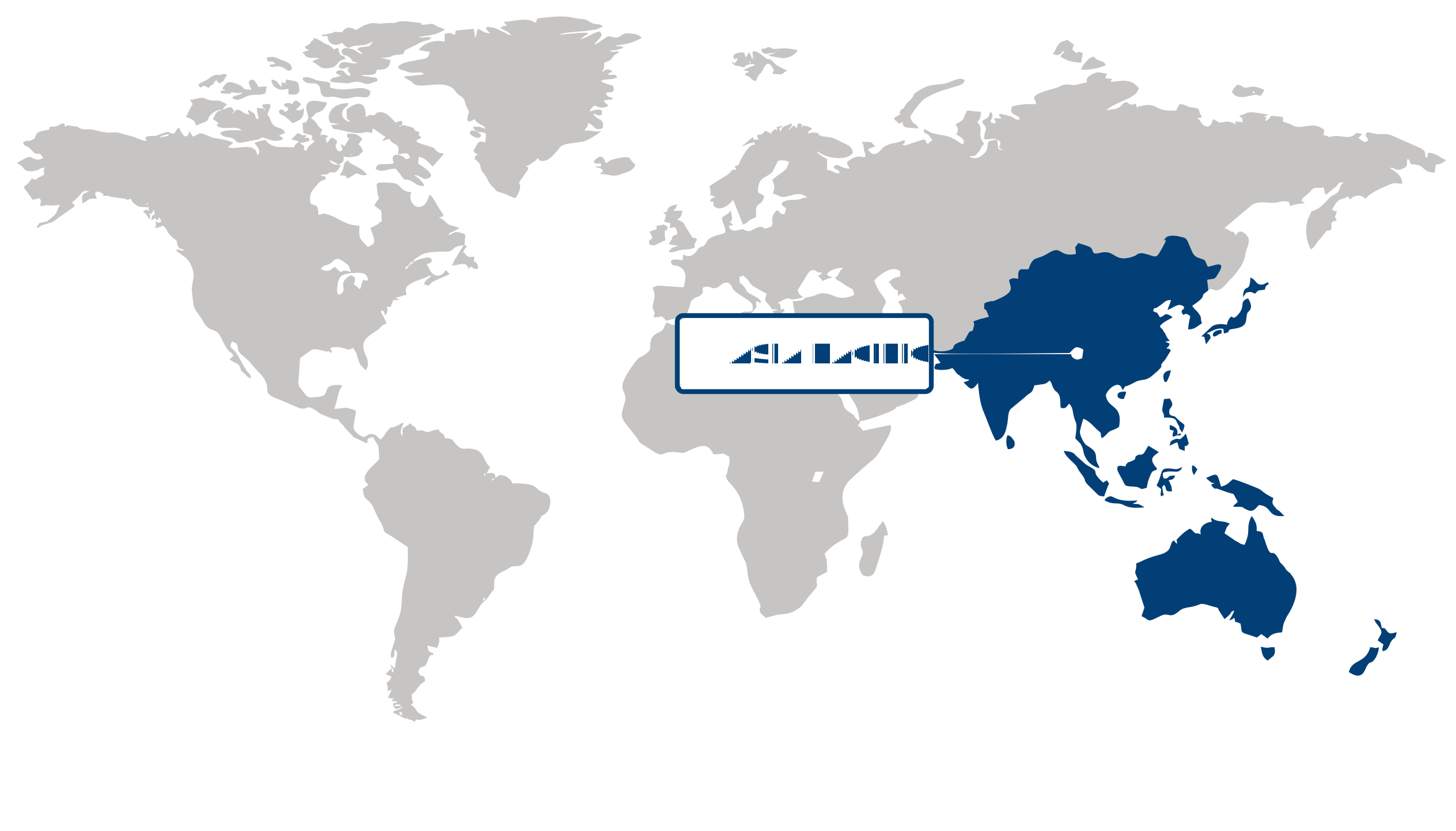
Largest Region
Asia Pacific
XX% Market Share by 2034
North America (U.S., Canada): The North American Airborne LiDAR market is expected to witness significant growth due to the increasing adoption of LiDAR technology in various sectors such as infrastructure, forestry, and transportation. The United States is the leading player in the North American market, owing to the presence of key market players and a high demand for LiDAR technology in industries such as urban planning, agriculture, and environmental monitoring. Canada is also expected to contribute to the growth of the market, driven by government initiatives for the development of LiDAR-based mapping and surveying technologies. Asia Pacific (China, Japan, South Korea): The Asia Pacific Airborne LiDAR market is projected to experience substantial growth, primarily driven by the rapid urbanization and infrastructure development in countries like China, Japan, and South Korea. China is expected to be a key market for Airborne LiDAR technology, with increasing investments in LiDAR-based mapping and topographic surveying. Japan and South Korea are also anticipated to witness significant growth in the adoption of Airborne LiDAR technology, supported by the expanding applications in forestry management, disaster management, and urban planning. Europe (United Kingdom, Germany, France): Europe is expected to be a prominent region in the Airborne LiDAR market, with countries like the United Kingdom, Germany, and France leading the market growth. The increasing demand for LiDAR technology in applications such as infrastructure development, archaeology, and environmental monitoring is driving market growth in the region. The United Kingdom, in particular, is witnessing a rise in the adoption of Airborne LiDAR for flood risk assessment and coastal monitoring, while Germany and France are focusing on utilizing LiDAR technology for smart city development and precision agriculture.
🔒 Need data on a specific country or region?. Individual country/region reports are available at discounted pricing. Inquire Before Buying
Segment Analysis

Segment Leadership and Growth Trends

Go beyond the chart, access full insights & data tables

Request Free Sample Report
Platform Type: The platform type segment in the airborne LiDAR market pertains to the various types of aerial platforms used for deploying LiDAR technology. This includes helicopters, fixed-wing aircraft, and UAVs (unmanned aerial vehicles). Each platform type offers distinct advantages and limitations in terms of flight range, altitude capability, and maneuverability, which can significantly impact the efficiency and effectiveness of LiDAR data collection. For instance, helicopters are well-suited for low-altitude mapping in difficult terrain, while fixed-wing aircraft are preferred for large-scale mapping projects due to their longer flight endurance and higher cruising speeds. UAVs, on the other hand, are increasingly being used for small-area mapping and precision agriculture applications due to their agility and cost-effectiveness. Component: The component segment in the airborne LiDAR market encompasses the key hardware and software elements that constitute a LiDAR system. This includes laser scanner, GPS/IMU (Global Positioning System/Inertial Measurement Unit), camera, and data processing software. The laser scanner is the primary component responsible for emitting laser pulses and capturing the reflected light to generate precise 3D point clouds of the terrain. The GPS/IMU system provides accurate positioning and orientation data for georeferencing the LiDAR data, while cameras may be integrated to capture high-resolution imagery for texture mapping and photogrammetric analysis. Data processing software plays a crucial role in post-processing the raw LiDAR data and extracting meaningful information for various applications. Application: The application segment in the airborne LiDAR market pertains to the diverse range of industries and use cases that leverage LiDAR technology for mapping, surveying, and monitoring purposes. This includes forestry, infrastructure, topographic mapping, power line inspection, and floodplain mapping, among others. In forestry, LiDAR is used for forest inventory, biomass estimation, and tree species classification. In infrastructure, LiDAR is employed for corridor mapping, highway design, and urban planning. Topographic mapping utilizes LiDAR for terrain modeling, landform analysis, and watershed delineation. Power line inspection benefits from LiDAR's ability to detect vegetation encroachment and identify structural defects. Floodplain mapping relies on LiDAR for flood risk assessment and hydrological modeling. The diverse applications of airborne LiDAR underscore its versatility and utility across multiple industries.
Custom Research

Unlock insights tailored to your business with our bespoke market research solutions.

Click to get your customized report now.

Request Customization →
Competitive Landscape

Competitive Landscape and Market Positioning

The competitive landscape in the Airborne LiDAR Market is characterized by the presence of several key players striving to gain a strong foothold in the industry. These players are constantly focused on innovating their LiDAR technologies and expanding their product portfolios to cater to a wide range of applications such as forestry, transportation, urban planning, and infrastructure development. The market is witnessing intense competition in terms of product development, pricing, and partnerships. In addition, technological advancements and strategic collaborations are further intensifying the competition among the market players. Top Market Players 1. Teledyne Optech 2. Leica Geosystems 3. RIEGL 4. Trimble 5. Faro Technologies 6. YellowScan 7. Velodyne Lidar 8. Merrick & Company 9. SICK AG 10. Quantum Spatial
Company Market Share Company Revenue Revenue CAGR (%) Product Portfolio Geographic Presence Innovation / R&D Focus Strategic Developments
No companies available.
🔒 This section is available as a standalone purchase. Buy only the data you need. Inquire Before Buying
Report Customization

Customize Your Report

Explore examples of how this report can be tailored to different research needs, including custom segments, additional topics or chapters, and related reports. Click a section of the wheel or its numbered marker to explore the available options.

1 Custom Segments 2 Custom TOC 3 Related Reports

Airborne LiDAR Market — Custom Segments

Segment Sub-Segment
No segment data available.

Airborne LiDAR Market — Custom TOC

Custom Chapter Chapter Details
No custom TOC data available.

Need a different cut of the data?

Request Custom Research
Frequently Asked Questions

Testimonials

Our Clients

"The reports offered a comprehensive view of the Food and Beverage landscape, covering market trends, consumer behavior, and competitive dynamics."

Business Development Head
Terma A/S

"Our experience in acquiring market research reports has been outstanding — the depth of analysis and actionable insights have proven invaluable."

Safety Manager
The Aerospace Corporation

"Fundamental Business Insights demonstrated a keen understanding of our business needs, delivering reports tailored to our specific objectives."

Procurement Officer
Kongsberg Gruppen
THE RESEARCH BEHIND THIS REPORT

Our Research Team & Methodology

Every Fundamental Business Insights report is built by a dedicated vertical research team, validated through a structured primary-and-secondary methodology, and reviewed for accuracy before it reaches you.

THIS REPORT'S RESEARCH VERTICAL

Research Team Overview

♢

Prepared by the Aerospace & Defence Research Team

10+
Industry Verticals
100+
Countries Analyzed
5–7
Days Standard
Delivery
12k+
Research Reports
Published
On-
Demand
Customized Research
Available
6
Months Analyst
Support
PDF + XLS
Report Deliverables

Trust & Compliance

☷D&B D-U-N-S
♢GDPR & CCPA Compliant
♙ISO 9001 Certified (ISO 9001:2015)
♙SSL Encryption
▭Secure Payments
✓Confidential Handling

Research Intelligence

Executive Leadership
Product & Technology Experts
Manufacturing & Operations Leaders
Procurement & Supply Chain Professionals
Sales & Commercial Executives
Channel Partners & Distribution Networks
Enterprise Buyers & End Users
Industry Consultants & Regulatory Experts

Research Workflow & Quality Assurance

📥
01

Data Collection

Verified information gathered through primary and secondary research.

🔍
02

Data Triangulation

Cross-validation using multiple independent data sources.

📈
03

Forecast Modelling

Market estimates developed using historical trends and analytical models.

👨‍💼
04

Analyst Validation

Findings reviewed by domain experts for accuracy and consistency.

📝
05

Editorial & Quality Review

Final editorial, quality, and compliance checks before publication.

✅
06

Final Publication

Released after successful completion of the internal review process.

Read our Research Approach →

Report Coverage

📊 Market Assessment

  • Market Size & Forecast
  • Market Segmentation
  • Regional Analysis
  • Growth Drivers & Challenges
  • Market Dynamics

🏢 Competitive Intelligence

  • Competitive Landscape
  • Company Profiles
  • Competitive Benchmarking
  • Mergers & Acquisitions
  • Market Share Analysis or Key Company Strategies

🔍 Strategic Analysis

  • Value Chain Analysis
  • Porter's Five Forces
  • PESTLE Analysis
  • Pricing Trends
  • Supply-Demand Analysis

🚀 Future Outlook

  • Technology Landscape
  • Regulatory Landscape
  • Investment & Funding Landscape
  • Emerging Opportunities
  • Future Market Outlook

Have a question about this report or need a custom scope?

Request Customization
License

Select License Type

Single User
US$ 4,250
Buy Now
Corporate User
US$ 6,150
Buy Now

Want this data scoped to your exact question?

Tell us the segments, regions, or competitors you need answered — an analyst will confirm scope before any custom work starts.

Talk to an Analyst →